
Accessing Ross County parcel data can feel confusing if you’re not sure what each file contains, where the official downloads are located or how to properly work with formats like GIS shapefiles, parcel layers or CSV property datasets.
This comprehensive guide walks you through everything step by step what the data includes, how to download it and the best ways to use it so you can explore Ross County property information with confidence and accuracy.
Whether your goal is to review parcel boundaries, check tax assessment details, verify acreage or analyze land for development, appraisal or investment, this expert guide provides a clear, detailed overview of every tool and dataset available through Ross County’s official resources. It removes the guesswork and helps you understand exactly how to navigate and work with Ross County parcel data effectively.
What Is Ross County Parcel Data? (Read This Before Downloading)
Ross County parcel data is the full collection of property-level information maintained and updated by the Ross County Auditor’s Office. It serves as the foundation for real estate research, tax assessment review, land development planning, and ownership verification.
This dataset is used daily by homebuyers, appraisers, surveyors, investors, researchers and local residents who need accurate, up to date property records.
What Ross County Parcel Data Typically Includes
Ross County’s parcel dataset provides a detailed profile of each property, including:
- Owner name and mailing information
- Parcel/PPN identification number
- Site address and geographic location
- Acreage, lot dimensions, and structural details
- Taxable value, assessed value, and estimated market value
- Annual tax amounts and assessment rates
- Land use and property classification
- Sales history and transfer dates
- GIS parcel boundaries and map layers
Because this information is updated on a routine schedule, it is one of the most reliable sources for accurate property research in Ross County.
How to Download Ross County Parcel Data (Step-by-Step Guide)
Many users get confused when downloading parcel files for the first time, but the process becomes simple once you know where to look. Follow these steps for smooth access to Ross County property data.
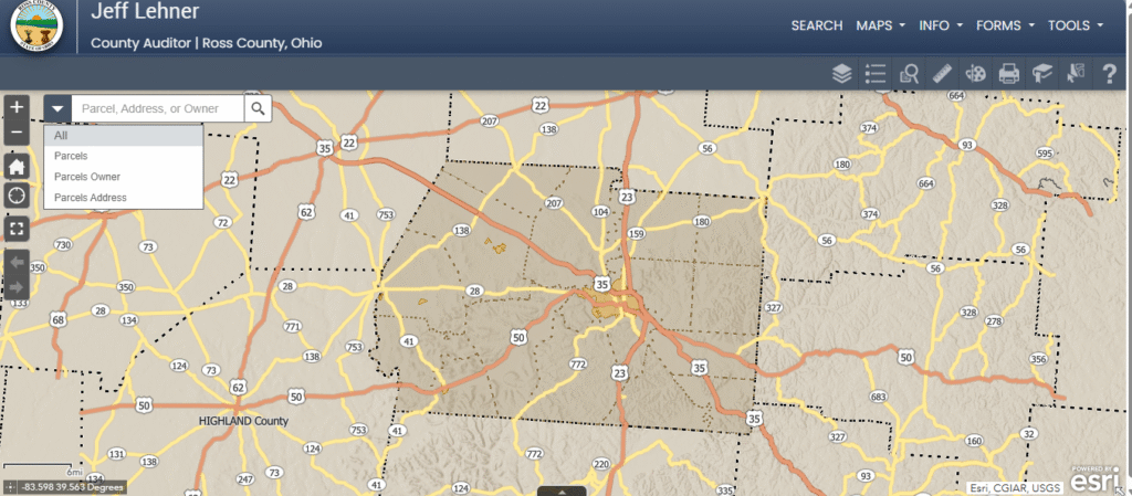
Step 1: Go to the Ross County Auditor’s Website
Open the official Property Search / Parcel Search page through the Auditor’s website:
Step 2: Search for a Property Record
You can lookup any parcel using:
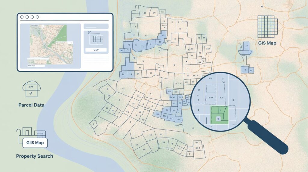
Step 3: Launch the Interactive GIS Map Viewer
The GIS portal allows you to visualize property-level data, including:
- Parcel outlines and shape files
- Boundary lines
- Land layers
- Zoning and geographic overlays
- Adjacent parcel information
This map viewer helps you understand the property’s actual footprint and surrounding land structure.
Step 4: Download or Export the Available Files
Depending on the tool you’re using, you can export several types of datasets, such as:
- GIS shapefiles for mapping software
- Property detail PDFs
- CSV parcel lists or data tables
- Printable map images and parcel layer exports
These downloads are especially useful for investors, surveyors, and anyone working with large property datasets.
Step 5: Save and Organize Your Files
Once downloaded, keep your GIS files, PDFs and CSV records organized for quick access especially if you’re working on research or long-term property analysis.
CLICK HERE TO VIEW AND DOWNLOADING PARCEL DATA, GIS OR CSV
How to Use GIS Parcel Data in Ross County (Practical, Real-World Applications)
After downloading Ross County’s GIS parcel files, you can use them to perform detailed land and property analysis. GIS data is especially valuable for professionals who need accurate spatial information.
1. Verify Exact Property Boundaries
GIS shapefiles let you view the precise outline of a parcel. This helps you:
- Confirm lot dimensions
- Identify shared boundaries with neighboring properties
- Measure distances, frontage, and acreage
- Review irregular or complex parcel shapes
This is crucial for survey preparation, fencing projects, and land-use planning.
2. Review Zoning, Land Use, Soil, and Environmental Layers
The Ross County GIS system allows you to overlay multiple geographic layers, making it easier to understand development restrictions or opportunities. You can explore:
- Zoning classifications
- Agricultural vs. residential land use
- Floodplain areas
- Topographic and soil data
- Public utilities and easement locations
These insights are essential for builders, investors, environmental consultants and anyone assessing development feasibility.
3. Compare Nearby or Adjacent Parcels
GIS data allows side-by-side reviews of surrounding parcels, helping with:
- Neighborhood value comparison
- Identifying similar property types
- Understanding ownership patterns
- Evaluating market potential
This kind of spatial comparison is especially useful for appraisers and real estate investors.
How to Use CSV Parcel Data (The Fastest Way to Analyze Ross County Property Information)
CSV parcel files are ideal for users who need quick, sortable property information without using advanced GIS software. They are lightweight, flexible, and easy for beginners as well as professionals.
What You Can Do Using CSV Parcel Data
CSV files allow you to:
- Sort parcels by market or assessed value
- Filter vacant land, agricultural parcels, or specific classifications
- Compare tax amounts across neighborhoods or subdivisions
- Identify ownership details or absentee-owned properties
- Analyze property trends in different areas of Ross County
- Review sales history patterns when combined with other datasets
These capabilities make CSV files a powerful tool for research and large-scale property evaluation.
Recommended Software for CSV Files
You can open and analyze CSV parcel data using:
- Microsoft Excel
- Google Sheets
- LibreOffice Calc
- Any spreadsheet or data analysis program
Because CSV data is simple and universal, it’s the easiest format for reviewing dozens or even thousands of Ross County parcels at once.
Common Issues Users Face and Practical Solutions That Actually Work
Even experienced users can run into challenges while working with Ross County parcel downloads. Below are the most frequent problems and the most reliable fixes.
Problem 1: GIS Files Won’t Open or Load Properly
Solution:
Install QGIS, a powerful and completely free GIS application. It supports nearly all parcel-related formats Shapefiles, GeoJSON, KMZ and more. If a file fails to load, drag it directly into QGIS or check that all accompanying files (e.g., .dbf, .shx) are in the same folder.
Problem 2: CSV Columns Look Broken, Shifted, or Hard to Read
Solution:
Upload the CSV file to Google Sheets.
Google Sheets automatically detects delimiters, corrects column breaks and formats large datasets more cleanly than many desktop programs. This instantly fixes misaligned property columns, parcel fields, or value entries.
Problem 3: Parcel/PPN Number Doesn’t Match Search Results
Solution:
Search again using the property address or owner name.
Parcel numbers in Ross County may change during data updates, especially after boundary adjustments, splits or consolidations. Address-based searches are often more reliable for locating the most current record.
Problem 4: Download Link Isn’t Working or File Is Missing
Solution:
Use the GIS map viewer’s “Export” or “Download Layer” feature.
The GIS map often provides the most updated shapefiles and parcel layers, even when the main website link is down or undergoing maintenance. Exporting directly from the viewer guarantees you get the newest version.
Conclusion
Accessing and working with Ross County parcel data becomes simple once you understand the tools and formats available.
- GIS files deliver precise spatial insight parcel boundaries, land layers, zoning, and geographic context.
- CSV data offers fast, sortable analysis for researchers, investors and anyone comparing multiple properties at once.
- PDFs and on-screen records provide easy-to-read summaries for quick reference.
This guide was designed to address the real challenges users face when navigating Ross County property data and to give you the confidence to download, interpret and use that information accurately whether for research, development or informed decision-making.
FAQ’s
How can I look up property records in Ross County?
Use the Ross County Auditor’s online Property Search to view ownership, values, taxes, and parcel details.
Where do I download Ross County parcel data?
Parcel shapefiles, maps, and exportable data are available through the county’s public GIS mapping portal.
How do I check the tax amount for a property?
Search the parcel on the Auditor’s website by name, address, or PPN to see current charges and payment history.
Can I see if a property is vacant or in foreclosure?
Yes. Auditor records show vacant land, and Sheriff Sale listings display foreclosure properties. GIS maps also help confirm land use.
How do I find a Parcel Number (PPN)?
Enter the address or owner name in the Property Search tool; the PPN appears at the top of the results page.